Ecological baseline studies aim to document the existing conditions of an ecosystem in its natural state before the onset of development activities. These studies establish a reference point against which future changes can be measured, thus it can be compared whether the project has had a negative impact – e.g. habitat and biodiversity loss, or whether it has achieved Biodiversity Net Gain.
The ecological assessment is key to list the biological resources present in the project area, and also to understand ecological processes such as pollination, nutrient cycling, and water cycle by the ecosystem. Similarly, the assessment allows for identification of ecosystem services such as carbon sequestration in forest’s biomass, flood regulation, and soil fertility.
Therefore, the ecological assessment should be done by robust professionals that not only are capable of doing fieldwork and collecting data based on established methodology, but are also be able to draw conclusions based on critical thinking, and connecting dots between biodiversity, habitats, and ecosystems services.
The following sections will provide an example of what an ecological baseline assessment will include.
For the purpose of this post, we will use as an example the development of a resort in a coastal tropical location, covering a 10-hectare area. The below methodology will provide a quick overview for a robust ecological assessment. There are several approaches to obtain similar results, and other ecologists might choose different methods, adapting to needs and availability of resources.
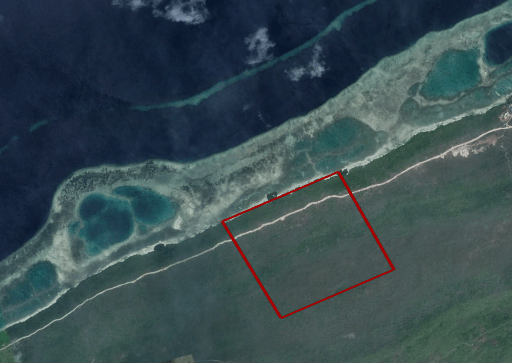
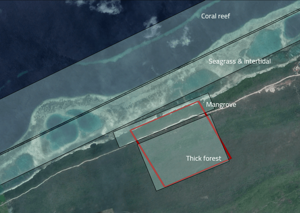
Map representing the project area (red square), and the surrounding environment.
General methodology
The evaluation of what is needed for the ecological assessment is done during the Scoping phase of the Environmental and Social Impact Assessment (ESIA).
Typically, it involves conducting a desktop-based review and field studies to gather comprehensive data about presence of species species, habitat, and get conservation insights. In some cases environmental modelling may be used to predict future changes in biodiversity and ecosystem services.
Desktop review
The desktop review is a preliminary process where existing data and information about an area are gathered and analyzed to evaluate its ecological characteristics. This review involves examining maps, aerial imagery, scientific literature, previous environmental studies, and databases. The goal is to understand the potential ecological values, threats, and sensitivities without physically visiting the location.
The desktop review also examines relevant regulations (like what species are protected by law), the location of the project with relationship to protected areas (hence evaluate habitat connectivity and migratory pathways), and what type physio-graphical conditions are expected.
Identification of the study area
The process begins with defining the study area, setting clear objectives, and developing appropriate surveying techniques. For example, based on satellite imagery, the ecologists need to zoom-in into the project site and identify what type of habitats are observed (done during the Desktop review).
Following the project example, while the development sits on the red square, it has a large area of influence (AoI) that directly affects the coastal waters. The AoI is included, as the project will have hotel residents using the beach and enjoying the coral reef. Thus, the survey should expand to this territory.
Two types of assessments should be conducted separately, one for marine+coastal, and one for the in-land environment. The marine study should tailor methodologies for mangrove, seagrass, and coral reef assessments. The terrestrial survey should focus on one type of habitat: the forest. In this location, it is possible that the terrestrial forest is the same mangrove from the coast. For the purpose of explaining the terrestrial methodology, let’s assume that the in-land forest is not a mangrove forest.
Identification of survey effort
The survey team should include both terrestrial and marine ecologists experienced in diving. A minimum of two ecologist should always be together, due to safety reasons (‘buddy system’). Depending on the expertise, both surveys might be conducted by the same people, although it is common to have ecologists specialized for each environment.
1. Terrestrial survey: since the survey is in a tropical region, on a thick forests, the biodiversity of species is expected to be very high, with diurnal and nocturnal species. A land area of 10 hectares is quite large (approximately 10 football fields), thus it might take a few days to survey. The ecologists can choose to survey over three to four days, by two people. It is recommended to account for extra time, as weather conditions might challenge access to survey areas.
The surveyors will split their time by covering ten random plots of 10×10 m each, where they will conduct a comprehensive species inventory. Additionally, they will use passive monitoring equipment to survey outside the plots. This might include deployment of ten trail cameras, and two bat detectors.
2. Marine survey: the same survey effort (four days, two surveyors) would be sufficient for the marine assessment, accounting for extra time in case of challenging weather. Based on the map, the area includes coral reefs, mangroves with a narrow beach, and potentially seagrass meadows and macroalgal forests in the intertidal zone. Each of those habitats have a separate approach for survey, and will be time consuming to move from one type to another. The ecologists might choose to focus one day on the corals, and the other days on other areas.
Selection of habitat types to tailor survey methodologies.
Both surveys should be treated separately, hence if the ecologists are specialized for both marine and terrestrial environments and will cover all the survey, the total effort would be six to eight days. This time does not account for the time that takes the ecologists to mobilize to the project site. Normally extra two days are added for mobilization and logistics preparations.
Survey approach
1. Terrestrial survey: Surveys should be representative of the habitat. In this case, sampling the ten proposed plots would provide a good overview for a homogeneous habitat as the observed thick forest.
If the location would have had multiple type of habitats (e.g. forest, grassland, riparian vegetation), the plots should not be random, and the assessment needs to cover all of them. In this case, maybe three plots of 10×10 m per habitat type would be adequate.
Passive equipment will be deployed outside the plots, for the entire survey length. The cameras and bat detectors will be spread across the survey site, in areas that will not be further interfered by humans. The intention is to collect data of elusive animals, that will then complement the active survey.
The main equipment needed for this terrestrial assessment includes a GPS, a smartphone-based field app (FieldMaps, Survey123, Fulcrum, etc.) to record observations, digital cameras, binoculars and standing scopes for bird surveys, field guides for species identification, and the trail cameras and bat detectors.
The ten random plots should be ideally mapped and uploaded into the field app before starting the surveys. Thus, the ecologists can see where they are at all times, by tracking their location in their phone. Otherwise, the 10×10 m quadrats can be chosen in-situ, and be measured with a reel tape, using flags or signaling tape to set the plots’ boundaries.
For other projects, additional assessments and equipment might be needed depending on the goals. For example, some assessments might require capture of animals for a high-level identification of species, thus it requires specialized equipment like mist nets to trap bats or birds, or hooks for snakes, or Sherman traps for small mammals.
2. Marine survey: since the marine habitats are very different, the approach will include:
- Diving for coral reefs, which will be surveyed at two different depths (maybe at 5 m and 10 m, depending on site conditions). On each depth, one or two approaches could be followed. One approach includes deploying at each depth, three 10 m chain transect following the rugosity of the coral reef. Another option would be deploying three 50×50 cm (or 1×1 m, depends on preference) quadrat grids at each depth. While the diving immersion could start from the beach, it would be more comfortable to do so from a boat, hence a boat rental should be planned prior survey.
- Snorkelling for seagrass meadows and intertidal habitats. Following a similar approach, ten 30 m chain transects can be deployed to assess the habitat composition along the transect. On each of those transects, it would be recommended to deploy one to three 50×50 cm quadrat grid, that will be used for species evaluation.
- Mangrove forests could be surveyed using a similar approach as for the in-land forest. For this exercise, the approach to be followed would be a walking transect along the entire beach boundary. Additionally, ten sediment cores will be taken to evaluate the animals living within the sediments (called infauna).
- Since the beach/coastal area shares the same boundary as the mangrove, both surveys will be conducted together, using the same walking transect.
The equipment for such marine survey will include binoculars for bird assessments, snorkeling and diving gear, boat rental, underwater cameras, underwater slate for taking notes, quadrats, measuring tapes with weights, or pre-measured chains.
Habitat mapping
This assessment allows for understanding the distribution and condition of habitats within the project area. In this project example, it will describe the extend and health of the coral reefs, seagrass meadows, and mangrove forests, as well as the in-land forest. It will help to define the conservation status on the project site, and evaluate habitat, biodiversity and ecosystem service losses one the forests is cleared out to build the resort.
The mapping starts with an evaluation of satellite imagery to create accurate maps of habitat types and their spatial distribution, to then require a ground-truth by snorkeling or diving, and with walking transects.
1. Terrestrial mapping: in this case, there is only one habitat, the thick forests.
2. Marine mapping: the habitats include coral reefs, mangrove forests, and an intertidal area that could have seagrass meadows, algal forests, or bare sand. Each habitat will be described separately, following different survey approaches.
- For the coral reef, the map shows the reef structure, but does not provide information of the health of the reef. It could be either be a healthy reef system with a high diversity of corals, or it could be bleached and covered by algae with no alive corals. The survey will calculate the percentage of substrate categories within the reef. Those categories can be: live coral, dead coral, bare substrate, algae grown on dead coral, coral rubble, rocks, sand, and other biotic elements. To calculate this, the ecologists will look at the type of substract falling at either each link of the transect chain, or within each grid of the quadrats. The final counts will confirm what proportion of that reef is actual live coral reef – hence understand the real magnitude of a potential impact from the development. It might happen that all the reef bleached (the coral died) in the past, and it is now overgrown by algae; in this case, the project impact will be less than if the reef were healthy.
- A similar approach will be followed for the intertidal zone, where a proportion of seagrass, algae, sand and rocky bottom will be determined, by counting links in the chain falling on top of that habitat type, or falling within a grid in the quadrat.
The mangrove forest and beach will not need a close-up habitat assessment, as both habitats are homogeneous.
Biodiversity inventory
1. Terrestrial survey: a representative snapshot of the project site will be evaluated with the ten quadrats, allowing for subsampling of what flora and fauna are present in the forest. It is expected that the forest is homogeneous, hence this approach is preferred – and there is no risk of leaving out of the survey important sub habitats with different species composition.
The ecologists will then carry out, via diurnal and nocturnal surveys, an inventory of all birds, reptiles, invertebrates, frogs, mammals, plants and fungi present in the area.
For the flora, they will evaluate the abundance of species within the quadrat using the DAFOR method (Dominant, Abundant, Frequent, Occasional, Rare).
Since this resort development will clear out the forest, additional assessments would be needed, such as evaluating the biomass of the trees, to then extrapolate the ecosystem value that will be lost. This could be done either by the surveyors (gathering biometric data from each tree within the plots), or by using remote sensing techniques such as LiDAR Scanning.
2. Marine survey: different techniques should be used, as there are benthic (on the substrate) and pelagic (swimmers) organisms.
- For the coral reefs, the biodiversity inventory is closely intertwined with the habitat mapping, as corals are habitat-building animals. The biodiversity inventory will focus on identifying the benthic species that fall on each chain link or quadrat grid. Hence, the ecologists will take note of substrate type (dead coral, live coral, coral rubble, sand, etc.), and of each observed species from various marine groups (corals, mollusks, sponges, crustacea, annelids, hydrozoans, algae, etc.).
- A similar approach will be used for the intertidal zone, with observations of what seagrass or macroalgae species fall on each chain link or quadrat grid, as well as what benthic animals are observed.
- Fishes are an important component of the survey, and separate assessments need to be done for the coral reef and for the intertidal zone. The approach is the same in both habitats. The ecologists will follow a belt-transect approach, recording a video while swimming along the transect. The recording will then be used to identify the observed species present within 1 m on each side of the transects.
- For the mangrove forest, the survey could follow a similar approach as for the in-land forest, with deployment of quadrats and evaluation of all species falling within the 10×10 m quadrats. But for this example, the approach is different (to teach a different method), and a walking transect will be followed. This is similar to the underwater transects, but in this case no chain will be deployed. The assessment will cover the entire extension of the mangrove, parallel to the beach. If the area were larger, subsampling would be required. Sediment cores will be taken for evaluation of infauna (worms, crustaceans, snails, etc.). Cores will be analyzed at a specialized laboratory, and not by the ecologists.
- The beach will be surveyed entirely and will target a bird survey. Hence, it should be conducted early in the morning and at sunset time, when birds are highly active.
Other assessments
While not for this project example, some projects might require additional baseline studies. For example, oceanographic surveys could be necessary to monitor factors such as currents, tides, and water temperatures, which can influence the distribution of marine life and ecosystem functioning.
Modelling is often include, specially to investigate the impact of sediments or nutrients release (from development’s waste) in sensitive habitats (like coral reefs). These studies assess the resilience of ecosystems to stressors, ensuring that any development activities are appropriately managed to minimize adverse impacts.
Next steps for protected species
When an ecological baseline assessment for an ESIA indicates that protected species are present within the development area, several actions are typically required to mitigate the impacts.
First, a detailed species protection plan must be developed to ensure that the protected species are safeguarded, which may include relocation efforts, habitat restoration, or specific management measures to minimize disturbance. Additionally, and applicable this project example, compensatory actions are needed to offset the loss of ecosystem services provided by the thick forest that will be cleared out to build the resort. This could involve habitat restoration elsewhere, with the establishment of conservation areas, or replanting native species to re-establish biodiversity and carbon sequestration services.
Challenges
Several challenges may arise during the conduction of ecological baseline studies. One common challenge is the seasonality of certain species or ecological processes. Some species may be migratory or only present during specific seasons, which can influence the timing of field surveys. Additionally, the baseline data collection process can be time-consuming and expensive, especially in remote or difficult-to-access locations.
Conclusion
Ecological baseline assessments are a critical step in the ESIA process, and are needed to evaluate the potential impacts of a proposed development on the environment, particularly on ecosystems and biodiversity. These assessments help identify sensitive habitats, protected species, and important ecological functions that could be affected by the project, allowing for informed decision-making. By understanding the potential environmental risks and the importance of ecological resources in the area, developers can design mitigation measures to reduce negative effects, ensure compliance with environmental regulations, and promote sustainable development. Ultimately, ecological assessments contribute to preserving ecosystem services, reducing biodiversity loss, and enhancing long-term environmental resilience.
